
Bicycle & Pedestrian | Transportation Planning Projects | Transit | Other Planning Projects
Transportation Planning Projects
Lake County Konocti Corridor Project
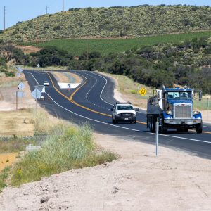 The Konocti Corridor project serves the communities of Lakeport, Kelseyville, Lower Lake, and Middletown, as well as facilitating auto and commercial truck traffic between U.S. 101 and Interstate 5. The newly constructed expressway aligns with the long-range plan to divert traffic from the northern end of Clearlake, where concerns regarding pedestrian and nonmotorized traffic safety have persisted. the successful completion of the $85 million Konocti Corridor project. This marks the first phase of a comprehensive safety initiative aimed at widening an 8-mile stretch of Route 29. The project’s funding was provided by Caltrans, the Lake Area Planning Council (Lake APC), and the Federal Highway Administration (FHWA).
Lake County Konocti Corridor Project
Eleventh Street Corridor Multi-modal Engineered Feasbility Study
The proposed study will analyze transportation alternatives along the Eleventh Street corridor within the City of Lakeport. Expanding on a recent City prepared right-of-way evaluation, it will examine costs and options for Complete Street improvements with a focus on expanding multi-modal use and improving safety for non-motorized and transit dependent users of the corridor. Improvements along the subject corridor, which is one the City’s primary east-west arteries to the downtown and lakefront areas, would be consistent with several goals and policies of both the Lake County Regional Transportation Plan and the California Transportation Plan regarding multi-modal facility needs, accessibility and safety.
Eleventh Street Corridor Multimodal and Engineered Feasibility Study_063020
Highway 20 Northshore Communities Traffic Calming Plan and Engineered Feasibility Study
Along the northern shore of Lake County’s Clear Lake, State Route 20 serves a dual role as an interregional throughway as well as a “Main Street” through several unincorporated towns, with roadside recreational and commercial uses playing a large role in their day to day activities. The proposed project will analyze current conditions and formulate traffic calming projects including bicycle, pedestrian and transit friendly options intended to improve the attractiveness and overall livability of the area. Input from County, Caltrans and Tribal government representatives, along with a series of community workshops, will be used to develop prioritized lists of improvements.
Final SR 20 Northshore Communities Calming Plan and Engineered Feasibility Study 6-10-20
Transit
Transit Development Plan
The Transit Development Plan is a five-year business plan for public transit in the region. The plan proposes several changes to Lake Transit such as implementing micro transit service in Lakeport and Clearlake Riviera, schedule changes to Clearlake Route 12 and reducing poor performing routes. (5/10/23) Update
Lake County Transit Development Plan (TDP)
Other Planning Projects
Lake County Wildfire Evacuation and Preparedness Plan
Lake Area Planning Council is preparing a wildfire evacuation and preparedness plan. The project addresses a recurring public safety need resulting from a number of catastrophic wildfire events in the County by setting standard evacuation protocols and procedures for relevant agencies. It will also be used to analyze the risk assessments of existing transportation facilities to determine potential strategies or improvement needs for vulnerable areas and populations.
Follow the link below to find more information regarding current status updates.
Lake County Wildfire Evacuation Planning Underway
Countywide Sign Inventory Project
This project will provide support services to agencies within Lake County involved with the roadway transportation system, aviation, bike/pedestrian, and transit planning in agreement with the goals and objectives of the Lake County Regional Transportation Plan. Previous work associated with this project includes the development of a countywide roads database; accident database; culvert, sign, and bridge inventories; speed zone database; and a bus stop and shelters database.